
Water runoff can wreak havoc on production. Adverse weather affects 45% of construction projects globally, resulting in extra costs valued in the billions, significant project delays, and potentially severe impacts on worksite safety and efficiency.
Localized flooding and spills are also intensely disruptive, particularly when overflow from a contaminated water source like a tailings dam might represent a regulatory violation and a steep fine.
Managing water runoff is crucial for minimizing erosion, preventing flood damage, protecting the environment, and keeping workers safe.
In this article, we’ll show you how Propeller’s hydrology tools help you simulate, plan, and manage water events on-site, minimizing disruption and ensuring operational continuity—even when the weather has different plans. For a quick overview of the hydrology toolbox, check out the video below.
Understand your site’s terrain
With an accurate 3D model of your site’s surface, you can measure elevations, slopes, and angles to predict how water will interact with your site, opening up a whole new world of possibilities.

With a solid understanding of your site’s terrain, you can:
- Control erosion: Uncontrolled runoff can undermine foundations, destabilize slopes, and increase sedimentation in nearby bodies of water. Preventing excessive erosion helps prevent costly rework and downtime, which can consume up to 20% of total project time if left unchecked.
- Predict flood patterns: Runoff can contribute to on-site and downstream flooding, impacting surrounding terrain and communities. When you know how your site will behave under various conditions, like a spill or heavy rainfall, you can take steps to prevent problems before they start.
- Adhere to environmental regulations: Water runoff carries pollutants like sediments, chemicals, and oil into local waterways, impacting water quality and potentially throwing you out of compliance. Protect nearby communities and avoid environmental fines by minimizing your site’s impact on local water quality.
- Shore up site safety: Heavy rains can destabilize material, making large stockpiles and steep slopes especially dangerous. By predicting where water will run and preventing problems before they snowball during inclement weather, you can mitigate risks and keep project workers safe.
We built our hydrology tools to address the above use cases, keeping worksites safer and more efficient in any weather. Let’s explore them in more detail, one by one.
Control erosion with runoff models
If you’ve ever wondered where water runoff or floodwater originated for a particular trouble area, Propeller’s catchment and watershed analysis tools answer that question.
These tools give you an instant visual of breached stream networks on any part of your site, showing you exactly where water will flow—and where it’s coming from. For any given point, these tools help answer the question: what would happen if the area upstream of this point were to breach?
Clear visuals help you identify weak points in a berm that could become problematic under heavy rain, pinpointing trouble spots that need work before the weather hits.
For example, a watershed analysis of your site might reveal that your entire worksite runs off into a single pond, flagging that you’ll need preventative measures like pumps and swales to prevent flooding. Or you might choose to regrade steep areas to ensure more even runoff across a landfill, adjusting slope angles to reduce water velocity.
There’s even a special tool for rainfall—Propeller’s direct rainfall simulation shows the effects of rainfall over time within a specified area, showing where water will pool and how well it will absorb based on parameters you specify. This tool looks beyond water volume and includes time as a variable to show where water will pool and how quickly.

It’s far better to know ahead of time that water will head straight for a stockpile or equipment storage area in the event of a storm, enabling you to move things around before the weather hits and prevent costly damage.
Anticipate flood patterns
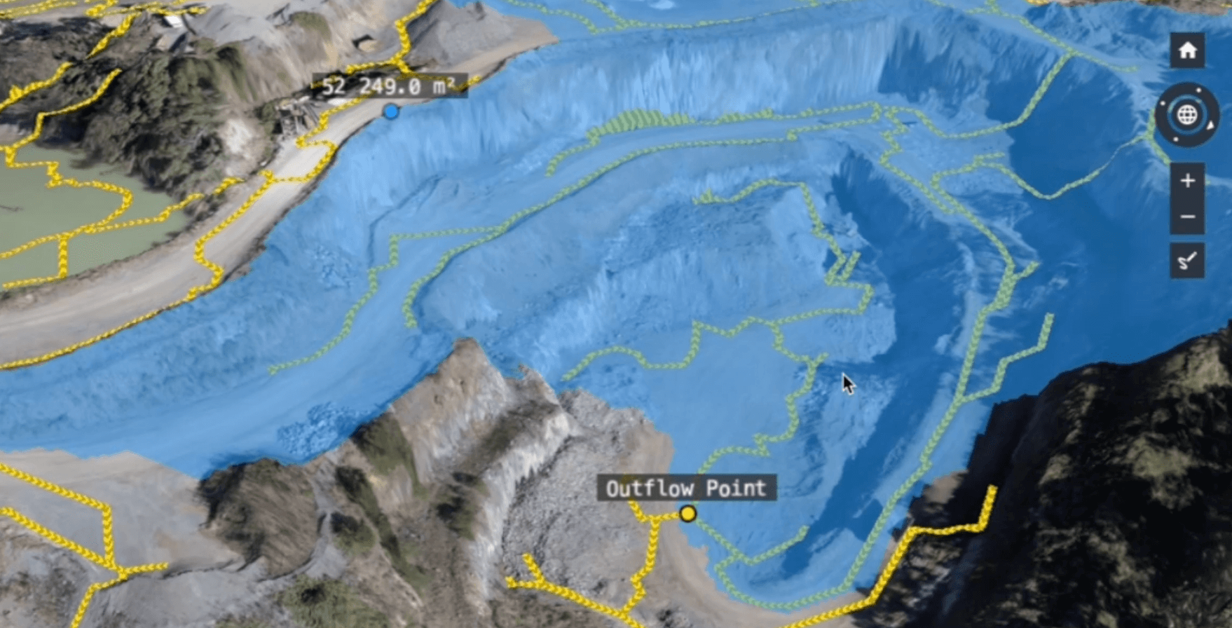
Using elevation data across a site’s surface, Propeller’s flood-to-level analysis displays the potential impact of a flood at specified water levels, helping you plan ahead in case disaster strikes.

Simply click any point on-site to see everything that would flood if water reached that level. This tool is incredibly valuable for spotting areas where water might run off from a catchment and cause damage, signaling the need to add downspouts, swales, or pumps to redirect stormwater.
Armed with this info, teams can adjust berm heights and site grades to protect stockpiles, equipment, and hard-earned progress if heavy rain and flooding are in the forecast.
Stay compliant with spill monitoring
Surface runoff simulations predict the path of water flow across a site in response to rainfall or spills. Simply draw a circle or polygon to create a boundary, then run a spill simulation for as much of your site as you want to see.

Runoff simulations are especially useful for legal protection and regulatory compliance, showing that sites are graded as required to prevent foundation flooding or excessive impact.
On a new green field site, these simulations help identify where to place drainage ponds and swale drains to capture water runoff. Mines can also pinpoint breach points into tailings dams using catchment and watershed analysis tools, highlighting how water will behave under different conditions.
Improve site safety
When you understand how water will flow across your worksite in the event of a spill or heavy rainfall, you can mitigate safety risks by increasing berm height, reducing water velocity and pooling, and increasing awareness of any problem areas.
For example, runoff simulations show where water will cut across a haul road, giving you time to make adjustments and prevent heavy erosion or washout. Our surface runoff tools highlight which downstream areas are at risk during a major spill or flood, helping teams plan accordingly and adjust slope angles as needed to keep critical infrastructure, workers, and equipment safe.
Rain or shine, we’ve got you covered
Water runoff can impact nearly every aspect of a civil construction site, landfill, mine, or quarry, from environmental compliance to structural integrity and project schedules. Maintaining stable site conditions, even during adverse weather, helps ensure continuous operation and reduces interruptions.
Proactive effort is the name of the game, and Propeller is a powerful ally in keeping your sites safe, efficient, and on track. With detailed 3D models to help visualize runoff scenarios, Propeller helps inform better project planning and design, reducing risks and ensuring smoother execution.


