Every contractor knows a dispute is a matter of when, not if. A GC challenges the grade. A sub denies damaging a utility line. A safety inspector questions trench compliance after the trench is already backfilled. These moments arrive fast, and without the right documentation, they’re expensive.
For subcontractors, the exposure is even greater. On large projects with multiple GCs and dozens of trades working in close proximity, blame travels fast, and it tends to land on whoever can’t prove they weren’t responsible. The work was done. The conditions were right. But if there’s no record, that doesn’t matter.
The contractors who walk away from these situations intact are the ones who don’t have to argue. They have the record. They have the timestamps. They have the data.
When memory isn’t enough
On a fast-moving site, conditions change by the hour. Dozens of trades working side by side, material moving in and out, work getting buried before anyone has a chance to document it. In that environment, relying on memory, or a camera roll with no coordinates, leaves you exposed.
The most common disputes on construction sites aren’t about who made a mistake. They’re about who can prove what happened.
A subcontractor damages a utility line that wasn’t marked. Another sub gets blamed. Without a permanent location record, it’s one crew’s word against another’s. A GC claims a slope wasn’t built to spec, but the work was completed and buried before anyone could verify. A safety inspector issues a fine for a trench that was compliant at the time it was open. The crew knows they were right. But knowing isn’t proving.
This risk is amplified on the largest, most complex projects (hyperscale data centers, major site developments, large infrastructure builds) where massive crews, compressed timelines, and dozens of subs working in close proximity create more opportunities for things to go sideways, and more parties ready to point fingers when they do. On a data center site specifically, the risk runs even deeper. Literally, underground. Power banks, fiber runs, cooling lines, and duct banks all compete for inches before they’re buried permanently. As we’ve covered in The invisible maze: 7 civil checkpoints for data center builds, most data center projects don’t fail because of one catastrophic mistake. They fail because of small, compounding gaps between design and reality that go unnoticed until it’s too late to fix them cheaply.
For subcontractors specifically, the multi-GC environment of a large data center build creates a uniquely difficult situation. Work sequences overlap. Trades hand off to each other constantly. And when a dispute surfaces (over a grade, a utility strike, a rework claim) the sub without documentation is almost always the one absorbing the cost.
Timestamped, visual documentation for every phase of the project
Propeller captures what happened on your site, when it happened, and what it looked like. Every survey, cross-section, and photo pin is tied to a precise location and a date. That record doesn’t change, doesn’t get lost, and doesn’t depend on anyone’s recollection.
Here’s how it works.
Go back in time with project timeline
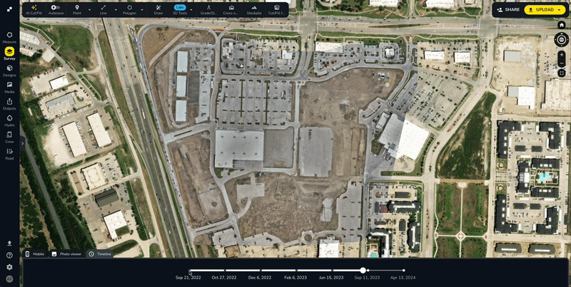
Every survey captured in Propeller is stored chronologically and accessible at any time. Slide back to any point in your project history and see exactly what the site looked like, what had been graded, what was untouched, and who was working in which area.
When a question about sequencing surfaces or an unforeseen condition gets disputed, your team can pull up the timestamped record in seconds. No back-and-forth. No speculation. Just the data.
One survey manager at a $500M excavation firm put it simply: “With visual proof from historical flights in Propeller, we shut disputes down before they even start.” That kind of defensible record isn’t a nice-to-have — it’s essential.
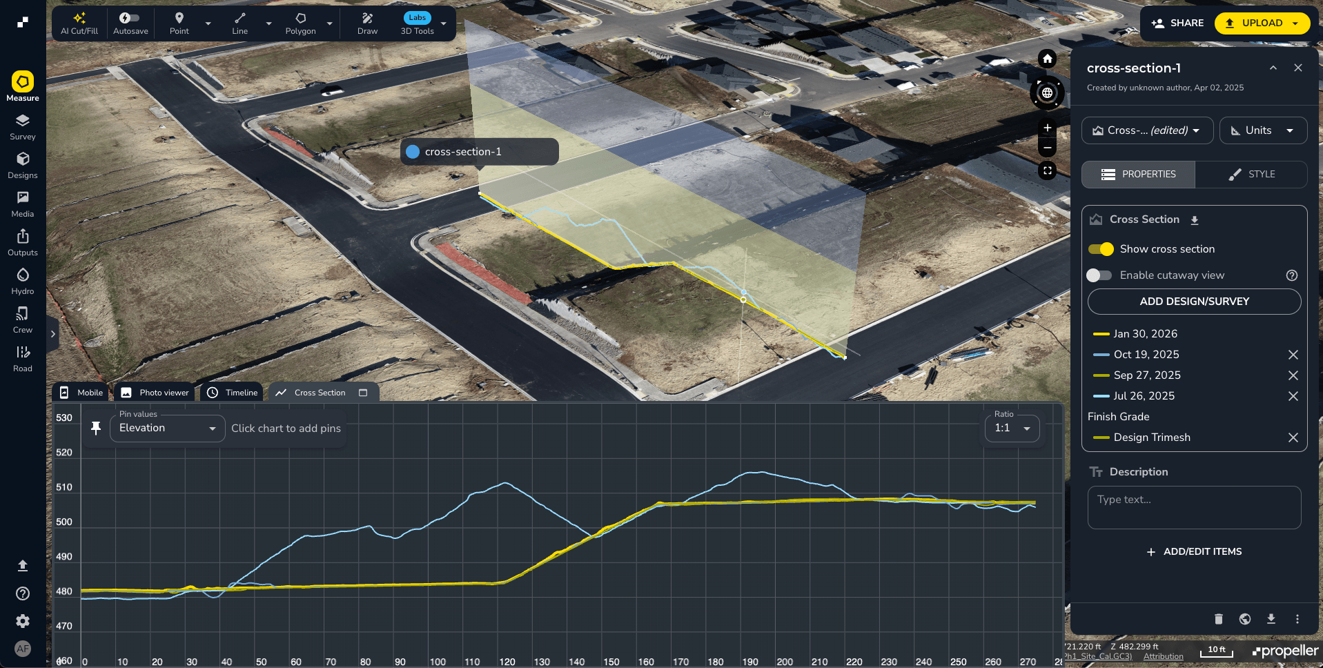
Prove compliance with cross-sections and grading tools
When a GC or regulator challenges whether a slope or trench was built to spec, a cross-section taken at the time of construction is the most direct answer you can give them.
Propeller’s progress tracking tools let you capture visual, measurable proof of exactly how a surface was built (trench depths, slope ratios) all referenced against your design surface. That data is tied to a timestamp and a precise location on the map. There’s no ambiguity about what it shows or when it was captured.
The real-world impact of that record is significant. One contractor using Propeller was facing a $400,000 rework dispute over slope construction. The GC claimed the work was out of compliance. The contractor pulled historical cross-sections from Propeller, showed exactly what the slope looked like at completion, and resolved the dispute on the spot. Another team used Propeller data to contest a safety fine over trench compliance; a fine that could have exceeded $100,000. The timestamped cross-section showed the trench was within spec when it was open. Case closed.
As the real cost of inaccurate construction data shows, the legal implications of failing to document site conditions accurately can make or break a firm. A verifiable, visual record is your first line of defense.
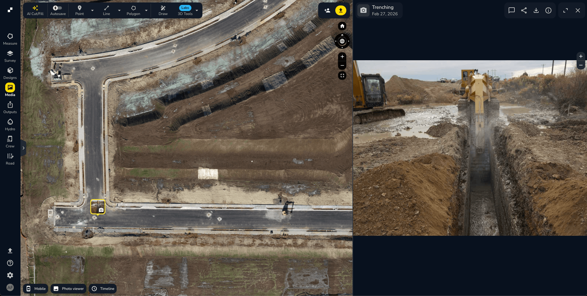
Create a permanent record with photo and media pins
811 paint marks fade. Utility flags get knocked over. Hand-drawn as-builts get lost. When a utility strike happens weeks or months after a locator marked the site, no one can agree on where the lines actually were. On data center projects (where utility corridor documentation before burial is one of the most critical checkpoints on the entire build) this gap is especially costly. Capturing as-built utility locations before they disappear underground is exactly where a missed step turns into a six-figure dispute.
Propeller’s field communication and collaboration tools let you document as-built conditions with geotagged, timestamped photos pinned directly to the map. Before you close a trench, drop a pin with a photo. Document site conditions before another trade moves in. Flag existing damage before your crew touches an area. That record stays on the map, linked to a precise location, for the life of the project.
Middlesex uses Propeller to track changes over time, knowing when and why a condition changed, with the documentation to support that record if it’s ever questioned. Kerr Contractors takes it further, using cut-fill measurements to keep subs accountable, identifying exactly where material quantities were distributed incorrectly and providing specifics on where work needs to be redone.
The record that protects your margin
Disputes don’t just cost money. They cost time, attention, and relationships. The teams that avoid them aren’t lucky, they’re documented.
This is especially true for subcontractors working on data center construction projects — some of the most complex, fast-moving builds happening right now. Multiple GCs. Dense underground utility networks. Trades sequencing work across a site that changes by the hour. In that environment, a subcontractor without a documented record of their scope is one disputed handoff away from absorbing a cost that isn’t theirs.
One project manager working on large industrial earthworks put it plainly: “The Propeller drone program saved us over $3M last year in preventing fines and rework.”
Propeller gives every contractor a timestamped, visual record of the work they’ve done. What the site looked like before they arrived. What it looked like when they left. What was built, graded, or buried, and when. When something gets challenged, you’re not scrambling to reconstruct what happened. You pull up the data, show the record, and move on.
That’s proof of work. And on a job site, it’s one of the most valuable things you can have.


